|
|
|
|
|
 | Author : Nicholas Bell | Version : 1.0 |
| Era :
Modern | Demo mission : No |
| Downloads : 13313 |
Rating : 4.3 / 5 (rated 6 times)
You must register before rating items.
|
| Included *.pbo files : | Needed addons : |
| N/A |
None |
| |
| Description : |
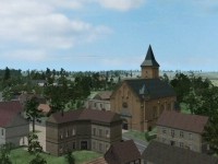
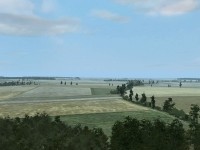
Schmalfelden is a map based on actual terrain in Germany, created using a military 1:50,000 scale topographic map (for elevation datum) and a Google Earth image of the area. I selected this area for recreating realistic engagements in a European environment which might typically described as "good tank country", terrain which Soviet Forces would have sought to exploit with their tank and mechanized infantry forces had the Cold War ever gone "hot". Another reason I selected this area was because unlike most of Germany, the farming communities in this area are very smal. Usually most towns usually are at least a square kilometer or two - these are half that. Hopefully the small size of the built up areas will help the ArmA AI.
Although the ground may appear to be flat (especially from the air) there are actually differences in elevation across the area of 50 meters. Making use of the valleys and draws are critical in your tactical maneuvering.
The map is also well suited for use in WW2 European scenarios. I also find quite a bit of fun to ride around on a motorcycle and explore the roads and trails and take in the sights from odd corners of the map. Flying NOE in a helicopter is also entertaining in itself.
This is a BETA version of the map - it is not finished. Road signs, road markers, power lines, street lights and other miscellaneous objects which bring "life" to a map have not been completed. There are not doubt objects which are currently not properly placed, eg building interiors with grass floors. (these are difficult to look at completely in Buldozer).
V.82 4 May 2008
1. Further improvements on satellite map.
2. Eliminated another 30,000 trees. Frame rate continues to improve.
3. Fixed several more ugly intersections.
4. Objects added: Additional road reflector posts, road signs, street lights in 2 towns so far, miscellaneous objects.
5. More building height problems addressed.
v.90 16 May 2008
1. Reduction of tree quantity in all forests now complete - a major task. Frame rates should show improvement.
2. Added additional fields with hay rolls.
3. Added brush to numerous locations along roads, lanes, and between fields. This consists of krovi_long bush type sunk 1.5 meters below the surface. When used in combination with Durg's Vegetation Fix, these low bushes provide concealment when the player is prone.
4. Eliminated incorrectly located road reflector posts in towns and farm roads.
5. Further improvments in roads and intersections. The road smoothing script doesn't seem to be going the best job for some reason, and many roads remain somewhat bumpy.
6. More improvements in the satellite image, toning down the bright fields.
7. I continue to find floating or sunk buildings which I am fixing. Some I swear I have already addressed. Either my memory is bonkers (probable) or Visitor has gremlins (possible).
8. Odds and ends you probably won't notice.
v.91 20 May 2008 Minor Update
1. Ladders and doors now work. Thanks to Fitzee on the BIS forums for his help solving my problems with this.
2. Fixed a mask conflict at the quarry entrance.
v.94 v.94 5 June 2008 (Plain Version - looks like previous versions)
1. Satellite image improvements.
2. Continued work correcting minor problems.
V1.0
Hundreds of minor fixes and improvements to object placement, satellite image and terrain mask.
Major noticeable changes:
1. Terrain speed modifiers fixed so vehicles will not speed across farm fields.
2. Satellite map resegmented from 512 pixels squares to 256 pixels squares. This increases the playing area of the map on the east
and south edge. It also allows for improvement in terrain mask. For example, there are areas the true meadow terrain now.
3. All versions can be placed in your addon folders and appear as seperate maps in the editor.
4. Signature keys included with each PBO.
5. Time to complete: 19 January 2008 to 27 June 2008. Approximately 340 hours.
|
| |
 |
| Size : 40.11 MB |
|
|
|
|
|
|
|
|


 0%
0% Arma Tactics released for PC via Steam.
 A new home of sorts for