|
|
|
| |
--=Terrain Starter Kit=-- by blackknight63 |
|
|
--=TERRAIN STARTER PACK=--
--=Blackknight63 Terrain Starter Pack=--
Download Link for Blackknight63 Terrain Starter Kit: FILE FRONT LINK
This pack was made to help people who have never made a map before, Make a Map!
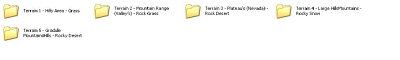
It includes 5 Terrain Templates (terrain.png's) 5 Sat_LCO's and 5 Masks! For the DEM/SRTM Data I used the USGS Seamless Server,Or I Made the Heightmap in GeoControl, I then imported the data into VTBuilder and used the area tool to export that to .bt format which I imported into L3DT and generated the Sat_LCO's! I have left the masks a standard colour to simulate the area of which they are based etc!
1. Hilly Area - Grass
2. Mountain Range (Valley's) - Rock/Grass
3. Plateau's (Nevada) - Rock/Desert
4. Large Hills/Mountains - Rocky/Snow
5. Gradule Mountains/Hills - Rocky/Desert
The Sat Maps are very basic but they give you an idea and a starting point to develop them further!
--=Instructions=--
Tools Needed:
Visitor 3
1st - Rename your this folder to the name of your terrain!
2nd - Edit all of the RVMAT Files in the "Data" Folder and the "layers.cfg" in the "Source" Folder so that "YOURTERRAINNAME" is replaced with the name of your terrain - I suggest Ultra-Edit!
------------------
1. Place the desired "terrain.png" in the "terrain" folder in side of the "source" folder!
2. Place the "Sat_LCO.png" and the "Mask_LCO" in the "source" folder!
3. Open up Visitor 3
4. Create a New Project
5. Set the "Terrain grid size" to "2048 x 2048"
6. Set the "Terrain cell size (meters)" to "10.0"
7. Click "Calculator..."
8. In the "Image size (pixels)" Field type "2048"
9. Click "Apply Proposed" the "Close"
10. Click "OK"
You will now see a blank blue background which is just waiting for you to start importing...hehe!
Wait!....
11. Click "Tools" at the top
12. Select "Project Parameters..." from the drop down list
13. In the "Texture layers" box click "Base (active)"
14. Click "Edit"
15. In the "Texture size" drop down menu slect "40.0x40.0m"
16. Click "OK"
Now it says (Invalid).....
17. Click "Calculator..."
18. Do (8.) and (9.)
19. Click "OK"
Now lets set up where we want Visitor to look for our "Data" Folder!
20. Click "Tools" at the top
21. Select "Project Preferences..." from the drop down list
22. In the "Folder - Textures" textbox put in "YOURTERRAINNAME\data"
23. Click "OK"
24. Now "Save" the project into the "Source" folder - (MAKE SURE YOU PUT ".pew" AT THE END OF THE NAME - EXAMPLE "yourterrainname.pew")
Right, now we can start to import all of the necersary data!
25. Click "Project" and then go to "Import Terrain from picture..."
26. Find your folder that is located in the "P:\" Drive then "YOURTERRAINNAME --> source --> terrain" and then select "terrain.pbl" - THEN SAVE YOUR PROJECT!
The heightmap should have shown up in Visitor 3!
Lets import the Sat_LCO and Mask_LCO
27. Click "Tools" at the top
28. Select "Import Satilite + Mask..."
29. Navigate to "layers.cfg" in the "source" folder
30. Select "Binary" and click "OK"
31 Selct the "Sat_LCO" and then select the "Mask_LCO"
32. Wait!
33. Open "Buldozer" by clicking the "Red Exclamation Mark"
34. Then, Without Closeing go to the Visitor 3 "Project Menu and select "Export World"
35. Save the .wrp file with the same name as your PBO, Make sure to save it in the PBO Folder, save it next to the "data" and "source" folders!
36. Now you can close "Buldozer" and "Visitor 3" - DO NOT FORGET TO SAVE IT!!
37. Open up the "config.cpp" and replace all of the "YOURTERRAINNAME" with the name of your PBO! and then you are ready to go, just PBO it and then go go go!
You can experiment with different terrain sizes and other different maps etc!
I have Included all of the L3DT Files so that you can edit it!
Have Fun!
DOWNLOAD - --=Terrain Starter Kit=-- - [138 MB 7z]
BIS Forum Topic |
|
| |
October 10th, 2008 - 09:31 |
|
|
|
|
|
|


 0%
0% Arma Tactics released for PC via Steam.
 A new home of sorts for